|
|
Maritime Topics on Stamps
|
| |
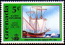
Vitus Bering,
Columbus of the Russian Czar!
|
|
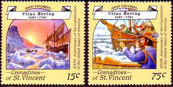
Vitus Jonasson Bering was born near Horsens in Denmark in the year 1680, and he died in December 1741 on the island
Awatscha, which has been named in honor him Bering Island.
He was a Danish marine officer in the service of the Russian czar. He commanded the two Kamchatka expeditions,
and for that reason nicknamed "Columbus of the Czar".
|
|
|
When Bering still was a young lad, he already sailed as a cabin boy on Danish ships to India.
But for any young boy living in the 17th century, Holland was the dream country.
During most of the 17th century the Dutch, traditionally able seafarers and keen mapmakers, dominated world trade,
a position which before had been occupied by the Portuguese and Spaniards, and which later would be lost to England.
It was the Dutch "Golden Century".
In Amsterdam he enlisted with a Russian recruiter and entered the service
of Czar Peter the First as a lieutenant. Soon he advanced to the captain's rank. He participated in the three Nordic wars
and the Russian war against the Ottoman Empire.
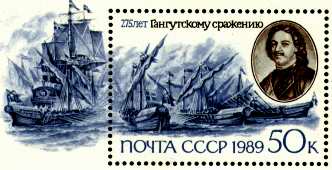
The stamp on the right hand side shows Czar Peter the first,
also named the Great, and a scene from the battle at Hangö, which the Russian fleet won against Sweden.
The three Nordic wars were fought for the supremacy in the Baltic domain, which Czar Peter won over the
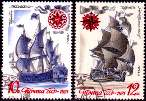
young Swedish king Karl the 12. On the left you see the battleships "Poltawa"(1712) and
"Ingermanland"(1715), which took part in these wars.
|
|
|
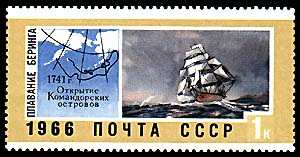
Bering became commander of the first Kamchatka Expedition from 1725 to 1730. Its mission was to find a north - east
passage from Asia to America, if it existed at all. His boat was the tiny sloop "Swjatoj Gavriil", only 18 meters long, and
he sailed along the Siberian coast northward bound.
He discovered many islands, but found no land bridging
Asia and America. At 67 degree 18 minutes northern width he turned back. Without knowing, he had already
passed the straits, which later were named the Bering Straits in his honor. But of course this was yet no proof,
that there was no connection further up north.
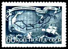
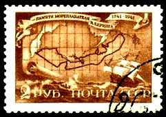
On the left hand stamp we see Bering and the routes of the first (the northern) and second Kamchatka expedition.
On the right is pictured a sloop of the second expedition. The "St. Gabirel" may have looked pretty much alike.
|
|
When Bering returned to Petersburg in 1730, he was advanced to the rank of a Captain-commander.
But he was also criticized for not fully completing his mission.
Bering himself therefore proposed a second exploration.
|
|
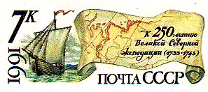
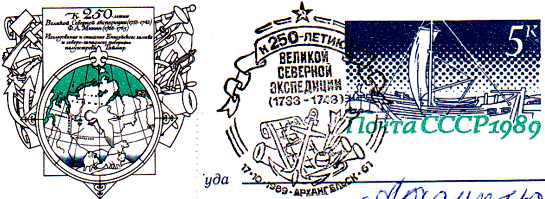
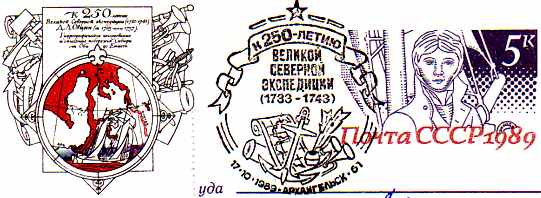
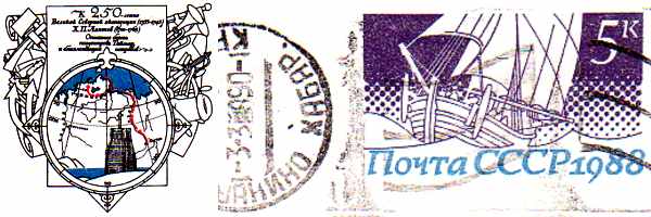
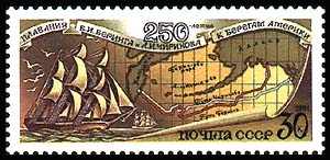
The second Kamchatka expedition was also called "The Great Nordic Expedition". It lasted 10 years, from
1733 to 1743 and was the biggest expedition of all times. Bering was its commander. Since czar Peter the Great
had died in 1725, the Czarina Anna authorized the 2. expedition.
|
|
|
The mission of the 2. Expedition was threefold: to explore Siberia, to prove or disprove a land bridge to America,
and explore a waterway to Japan via the North - East passage.
| |
Therefore the expedition split up into 3 groups. Map makers had to draw up maps of the northern and eastern areas.
Siberia had only been annexed to Russia in the late 16th century and little was known about its treasures.
Their work is shown on the three postal stationeries. They were successful as long as there were rivers,
but the ice sea was definitely the end of it. Boats were lost, people died.
|
|
The so-called "academic group" was to study the people and their customs, and the animals and plants of Siberia.
Finally the third, the "pacific group" with Bering leading, went strait through and on in search for new sea routes
and unknown coasts east of Siberia. Several German explorers and scientists joined the expedition.
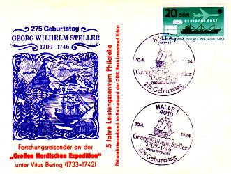
Georg Wilhelm Steller was particularly noteworthy.
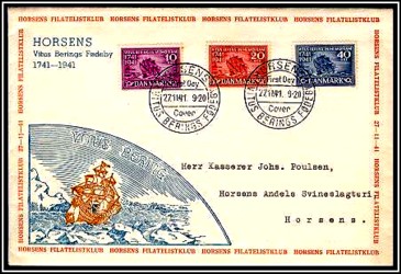
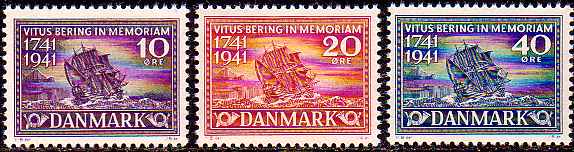
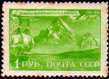
The Danish stamps issued on Bering's 200th anniversary of his death in 1941 show his
vessel the "Swajatoj Pjotr" or "Swiatoj Pietr" (in English "Saint Peter") in front of the Bering Island.
|
|
|
We do not know the exact number of expedition participants, but it must have been several thousands.
It was like a nation's emigration. Since they had to plan for several years ahead, professors, explorers and officers
were allowed to take their families along.
Everything, which they might possibly need, was packed up; even the piano
of Bering's wife. And for the boats, which they would build, they had to carry canons, ropes and a complete rig.
The towns through which the expedition passed had to provide accommodation and provisions.
On top, Bering's people confiscated everything useful to them. "Useful" ranged from horses and boats to inhabitants,
which Bering took along as expedition helpers. For any town along the way the arrival of an expedition group was
like an "Egyptian plague".
|
|
|
It is to Bering's merit, that the endeavor did not end up in total chaos. Professors requested better conditions
for their personal well - being, and among the troops refusals to obey and desertions happened almost daily.
A fire destroyed the scientific library. Messengers from the Czarina brought new orders to explore other regions.
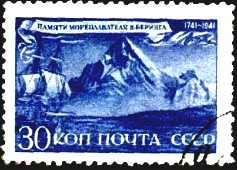
It took Bering 4 years to reach the Ochotskian sea. Now they built two vessels.
On the two stamps we see the "St. Peter" and the route of the ship.
|
|
|
The ships had three masts and measured about 24 meters. The "St. Peter" was under Bering's command,
the "St. Paul" under his companion Tschirikow. In September 1740 they started from Ochotsk and headed
for the southern tip of Kamchatka.
The German nature scientist Steller went with them as a medical scholar. Having reached Kamchatka they
stopped at Petropawlowsk (Peter and Paul's harbor). Following one report Bering had founded this town.
They left in June 1741, course on Alaska.
|
| |
After two weeks a storm separated the two boats. Bering and Tschirikow have never seen each other again.
Tschirikow hit Alaska in July 1741 near today's town of Sitka. He sent his two rowing boats to the shore.
Both boats did not come back and the 14 sailors had disappeared for good. There was no third boat on
the "St. Paul". So Tschirikow turned and sailed back home. The "St. Paul" arrived in Petropawlowsk in October 1741.
|
|
|
Meanwhile Bering hit the Alaska shoreline 600 km further up north. They also stopped at some of the Aleuten islands.
Bering pressed forward, since the winter came quickly. The scientists however requested more time for their research.
In November the "St. Peter" anchored off shore of the island Awatscha, which was later named
"Bering Island". It was rocky and bare , no woods. 34 of Bering's men were sick from scurvy.
They rowed ashore and found some fresh water and green cress for a healthy salad.
When a storm came upon them, the anchor chain broke and the ship touched ground.
Another report says the ship actually stranded. Either case, they had now to stay for the whole winter and hibernate.
|
|
The men dug caverns into the ground and covered them with tarps and planks from the "St. Peter".
Cold, hail, snowstorms and undernourishment took their toll. 18 men died, including Bering. He died in December 1741.
Some reports claim, that he died of scurvy. But Steller noted: "He rather died from hunger, coldness, thirst and sorrows,
than from scurvy or any other illness."
|
Some nevertheless survived. When summer came, they built themselves a boat from the parts of the stranded
"St. Peter". In August they left Bering Island and sailed to Kamchatka in only 11 days.
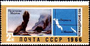
On the left-hand stamp there can be seen the rough cliffs of the Commander Islands, to which the Bering Island
belongs (I is the left hand island on the map).
|
|
|
On the 2. Kamchatka Expedition Steller described the inhabitants and their customs and behavior. He also
documented a large number of plants and animals. The "Steller's Sea Cow" became widely known.
Steller drew this animal in great detail. Thereupon the sea cows became a primary target for the fur hunters.
The last of its kind was likely killed already in 1768 near Bering Island.
Steller died too, in November of 1746 on his return, in Tjumen, which is in the Ural mountains.
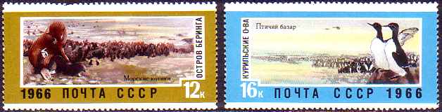
The two stamps document the wealth of different animals on these islands. On the left are shown some Seals
and Sea Cows, on the right there is a colony of a rare species of seabirds.
|
|
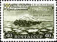
|
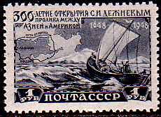
The first European passing through the Bering Straits was a Cossack, Semjon Iwanowitsch Deschnjow. He was a
seafarer, and he sailed with five boats from the mouth of the Kolyma river in north Siberia, through the Bering Straits,
and on to the mouth o f the Anadyr river at Tschuktscht peninsula.
This is shown on the left hand stamp. On the right hand side, you see Asia's outmost tip near the Bering Straits.
It carries his name, the Cape Deschnjew.
|

|
|
|
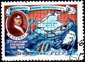
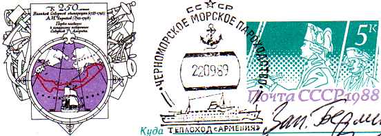
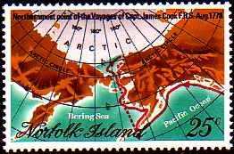
Eleven geographical sites have been named Bering. On the stamp in the middle is the Bering Sea;
behind it the Bering Straits. The Bering Island is close to the "f" in Norfolk. The red line shows Cook's
route in 1778. On the right there is Petropawlowsk, Bering's harbor for "St. Peter" and "St. Paul".
On the left hand stamp the Bering bridge is shown symbolically. Scientists believe, that at times
such a stripe of land existed and allowed the first humans to immigrate from Asia into The Americas over land.
|
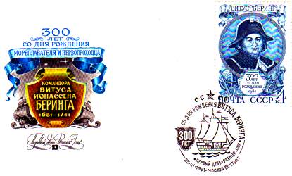
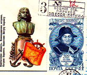
First day cover-letter, celebrating Bering's 300th birthday.
|
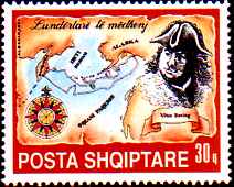
Albanian stamp 1991
|
In 1991 a Russian-Danish expedition found Bering's burial site. They analyzed teeth and bones and concluded,
that he did not die from scurvy. And also, Bering could not have had such a round face, which you find on many
pictures. Actually he had a strong body, but a delicately noble face. The man Bering shown on many pictures may
possibly be the writer Vitus Pedersen Bering, who is an uncle of "our" explorer Bering.
When you look through the literature, you will notice differences in the dates.
This is because sometimes the dates refer to the Julian calendar, which was used in Russia,
sometimes the dates refer to the Gregorian calendar, which was in use in most of Europe.
Therefore we renounced from giving exact days.
|
© Bjoern Moritz, all rights reserved.
|