|

|
Maritime Topics On Stamps :
Navigation !
|
In earlier times the Mariner's compass consisted of a circular
card, divided into 32 points, half points and quarter points like
it is shown on this stamp. Today it is divided into 360 degrees.
In the background you can see a seachart of the swedish coast as well.
|
In early history of seafare the sailors stayed closed to the coast and used landmarks for navigation.
At night they steered by the stars e.g. the Northstar in the Little Bear was wellknown.
They used him not only for their courses but also for getting time with a nocturnum.
On this stamp you can see how to find the Northstar with the aid of the Big Bear.
If there wasn't a coast nearby the Phoenicians looked at the sky for guidance.
In the commonly cloudless Mediterranean sky the sun gave them their direction.
The east was know as 'asu' (sunrise) and the west as 'ereb' (sunset).
Today you can find these terms in the names of Asia and Europe again.
Furthermore the sailors used the seasonal winds like the Passat and monsoon,
the sea currents, the depth, the clouds and/or the passage of birds to find their
way across the sea.
|

| |
The Vikings used the Pole Star, the sun, wind direction, currents,
temperature, water depth and colour, foggy areas and birds for navigation.
This was supported by the use of three excellent instruments: the sun
bearing plate, the board of sun shadows and the sun stone.
|

|
The bearing plate was used to determine the directions to sunset(west) and/or sunrise
(east) mark them with a needle.
The board of sun shadows consisted of a pane with a nail punched
through the centre and several concentric circles around. The nail was
configurable and cast a shadow on the pane. The length of this shadow
was used to determine the breadth. The stamp shows Leif Eriksson,
who reached America in the year 1001 with the help of a board of sun
shadows.
The sun stone was a Cordierit (a Silikat). If a Cordierit is
held in an right angle to the sun, the normally yellow crystal is changing
its colour to dark blue. Amazingly this also works when it is foggy or the
sky is cloudy. To know the direction of the sun the Vikings just had to
turn the stone until it went blue.
|
|
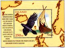
Rabe (="raven") Floki got his name from three ravens he carried on his
ship, when he searched for the location of Iceland. One day after leaving
the Foroyar islands he released the first raven which headed back for the
islands. On the second day he released the second raven, which came back
after circling for a while above the ship. The third day saw the raven
leaving for a northwesterly direction. Floki followed and reached Iceland.
|
|

|
The most important navigation instrument is the compass. It was invented by the Chinese
and reached Europe by Arabian merchant men.
The compass consisted of a magnetic needle which swung on a point and showed the
direction to the north. (The first Chinese compass showed to the south.) On this stamp
we see the first compass of the world, a chinese 'spoon compass'.
|
|
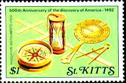
On this stamp you can see some nautical instruments from the start of the 16th century: A
compass to show the direction, a cross-staff to measure the astronomical angle and calculate
the latitude, a divider to use with the sea charts, a nocturnum to check the time and an
hourglass. In those times the only clock aboard vessels was the hourglass. It was mainly
used for changing the watch, although it had major drawbacks: Sometimes the sailors forgot
to turn the hourglass in time or the sand got wet and cloddy, which rendered it useless for
navigation as well.
|
|

|
Over many centuries the only method to locate the position on the oceans was to look at
the stars. To do so one person had to measure the height of the stars over the horizon by
the use of a cross-staff, a back-staff, an astrolabe, a quadrant, an oktant or (since 1731)
a sextant. Since a lot of sailors using the cross-staff became blind (they used to target
the sun for navigation) the explorer John Davis invented the back-staff (depicted on the
stamp to the left).
| |
From 1585 to 1587 John Davis made three voyages to search for the famous Northwestpassage.
The 'Davis-Street' between Greenland and Canada was named after him.
The quadrant, the oktant und sextant will be presented on the following stamps.
|
Captain James Cook, the famous explorer and cartographer. Here he is shown with an octant,
a logglas and a handlog. The log was used to measure the speed of a ship.
To the left of Cook's hand you can see the wooden end of a log which was thrown into the sea.
The logglas was an hourglass which ran for 14 seconds before it had to be flipped over. The
logrope was knotted in intervals of seven meters. The speed of a vessel was measured by
throwing the logrope into the sea and counting the outgoing knots of the logrope during these
14 seconds. The term knots as used for 'seamiles per hour' originated from these instruments
and this procedure. Likewise the term logbook originated from the handlog.
|

|
|
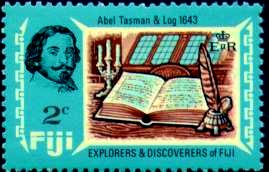
The most important document aboard every ship is the logbook.
Every day, be it on sea or at a port, will be registered in this book.
The position, the course, the speed, the wind (force and direction), the height
of the sea, the visibility, the clouds, the temperature of air and water,
the movement of the the ship, every unusual event and nowadays even the rotation
of the ships engine will be recorded.
On this stamp you can see the logbook of Abel Tasman. He explored the island Tasmania,
which was named after him, New Zealand, the Tonga Islands and the Fiji Islands.
|
The procedure to calculate a ship's position by it's steered course and it's supposed
speed is called dead reckoning. Of course this method is based on guessing, but
when the weather situation was bad and there was no chance of getting a look at the sun
this was often the only help.
If a sailing ship has to cruise against the wind it has to change direction very often.
For logging purposes you must mark every change of course in the seachart.
If you have to change the course twenty times or more during a day it is easy to simply
forget to record a change. The stamp to the right shows a table used by sailors to
keep track of course changes: They towed a small rope for each cruise-course through the holes
at the bottom.
|

|

|
Here you can see the head of Columbus, a quadrant, an hourglass and a compass card.
In the background the Atlantic Ocean is depicted with the dominate wind directions and
the course of Columbus' first voyage. For his voyage to America Columbus started on a
southerly route to use the northeast trade winds. Homebound he went northerly to reach the
western trade winds.
Today the direction and average strength of all winds, the currents, the tides, the swell and
the proposed weather conditions for all seasons are documented in books, atlasses and computer
programs worldwide.
They belong to the nautical equipment of every ship.
|

|
The stick charts of the Marshall Islands were a quality navigation help.
They were constructed with palm leaves and cocos fibres connected at exact points.
Twisted snail shells marked islands and special bend sticks showed the direction of the swell and
the motion of the sea. Long crossing lines told something about the destination.
There are a lot of stamps with stick charts, especially from the Marshall Islands.
|
Long before his four voyages to the 'New World' Columbus had learned to draw charts.
On this stamp you can see him studying a sea chart.
The greatest success in designing sea charts
belongs to the German cartographer Mercator. In 1569 he demonstrated his first sea chart, where the longitude lines were going parallel from north to south. Of course this was not correct and to avoid the chart becoming severely distorted Mercator stretched the latitudes.
Now one was able to mark courses and bearings as a straight line into the chart.
This design never changed up to today.
|

|

|
If one calculates a ship's position by observing the stars we are speaking of astronomical
navigation. If one measures the highest point of the sun at high noon, we know that the sun
will be exactly on a north-south axis. With a simple calculation you can get the latitude of
your position. This method was used by sailors during the time of the Middle Ages.
|
|
It was more difficult to calculate the geographical longitude. The earth is rotating and all other
stars are rotating as well on their way through the universe. The solution is to determine a
fixed point for all calculations. Thus the Zero Meridian of Greenwich was introduced.
When one is measuring the height of the sun he has to stop the exact Greenwich time.
Then it is possible to calculate a position line with the help of nautical tables to get the longitude.
The English man John Harrison constructed the first exactly running chronometer in 1735.
On this stamp you can see William Bligh, the captain of the 'Bounty', with his chronometer.
|

|

|
A liquid magnetic compass in a box with his gimbal. The gimbal holds the compass always in the
horizontal position, independent from the rolling and pitching of the ship. Behind him you can
see a bearing compass with the bearing top. In the background a radar antenna and a radio
direction finder antenna are shown. The bearing compass will get you the direction to a visible
land- or seamark. The radio direction finder is used to find a radio beacon which acts exactly
like a landmark. You take a bearing to a known seamark or
landmark, read the direction off the dial and calculate it to a geographical angle. The
result is used to calculate a position line you can use on a sea chart.
|
|
RADAR is the abbreviation for Radio Detecting and Ranging. The scanner/transmitter
antenna sends out a powerful ray which will be reflected back by certain objects.
Objects include other ships, islands and coastlines. They will be shown on a radar screen
complete with directions and distances. This is a very important tool during bad weather
conditions where visibility is often reduced to a minimum ( like fog). The radar is utilized
for coast navigation as well. It saw it's first use during World War II to detect
incoming German planes over Britain.
|

|

|
In business shipping the times of the magnetic compass are gone, he was replaced by
the gyro compass. Here we see the first functionally one gyro compass, contructed 1908
by Hermann Anschuetz-Kaempfe at Kiel, Germany. The force of the rotating earth
effect on the axis of the gyro compass to show to geographic north. This is an physical rule.
Today we have a mother compass with two roting gyros in a special room. This compass
is connected to a different number of displays on the bridge called daughter compasses.
Only the speed of the ship has a small neglecting influence to the compass.
|

|

| |
Here you can see the symbolic waves of an echo sounder to measure the depth of the water.
Similarly to the radar a sound transmitter sends out a signal to the ground and the echo
comes back up to the sound receiver. By measuring the runtime the echo sounder can calculate
and show the depth on his screen.
|
Today you determine a ship's position by satellite navigation. The position will be calculated
by the use of three radio signals from three different satellites and be displayed aboard
in latitude and longitude. This system,
the GPS - Global Positioning System was developped by the military as well. Today
it is in use on every ship, small yachts and even in cars as well.
Navigation is reduced to a simple look at different screens and to learn how to switch the
electronic devices on and off. No longer of interest for the study of elder generations.
|

|
Today you can buy sea charts for your personal computer and take it aboard.
Professional ships use fully electronical sea charts. On this stamp you can see
a display with an electronical chart.
But one thing must not happened:
The collaps of the electric power! Then you have to change back to old methods of navigation.
|
|